Outdoor Links
Hike Arizona
Trip Planning Guide
Trip Report Index
Calendar of Events
Library
Superstition Mountains
Trekking in the Land of Legends
December 2, 2000
by Chuck Parsons
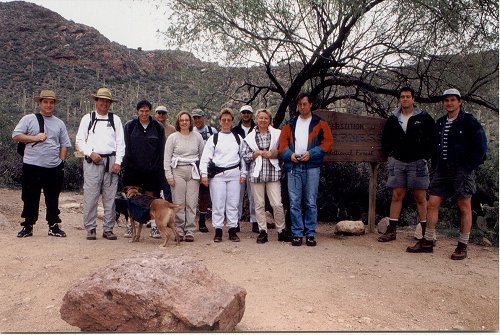 Thirteen ambitious hikers pose at the Peralta Trailhead. |
|
At 8:15 AM on a cool and overcast December morning in the desert foothills of the Superstitions, thirteen Motorola Hiking Club members and guests gathered around the Peralta Trailhead sign at the north end of the upper parking lot for a group picture, before starting our hike to the base of Weaver’s Needle, the most dominant and well-known landmark in this vast and legendary place known as the Superstition Wilderness. Our adventurous group of thirteen included Dan Bishop, Loyd Cook, Candi Cook, Anatoli and Natasha Korkin, Adam Kostewicz, David Langford, Reza Minaer, Chuck Parsons, Donna Schwitz, Steve Shaw, Tom Van Lew, and, last but certainly not least, our illustrious club president, Mike Wargel. The somewhat tortured and rugged appearance of this present-day landscape reflects the most violent and extreme forces nature can render in the form of powerful volcanic eruptions, lava flows, and hot ash and acids raining down from the skies. Responding to mysterious and unbelievably powerful forces unleashed from deep within the earth nearly 30 million years ago, this once relatively flat and peaceful open country yielded itself to a series of extremely violent volcanic eruptions that would continue intermittently for the next 10-15 million years. Over the course of this vast expanse of time an estimated 2500 cubic miles (yes, miles) of hot ash and lava would erupt from the bowels of the earth and explode high into the atmosphere, depositing billions of tons of debris back onto this now totally transformed and tortured landscape. The largest of the resulting collapsed calderas in this vast volcanic field would yield to yet another long siege of volcanic activity that would thrust its center thousands of feet upward to form the present-day Superstition Mountains. Millions of years of erosion and the scouring action of monstrous flash floods ripping their way through the inner canyons would give the Superstitions their current worn and weathered appearance. Weaver’s Needle itself, known as a volcanic plug in geologic terms, is the result of the eroding away of the softer surrounding volcano, leaving behind the harder lava that solidified in its neck. Starting out from the Peralta Trailhead at 2400 feet, under a high thin cloud cover and with a temperature of 60°F., our intrepid party of thirteen entered this land of myth and legends called the Superstitions. The very name itself conveys a certain sense of mystery and anticipation. Will we be the “Unlucky Thirteen”? Let’s hope not. The Peralta Trail winds its way north through the base of Peralta Canyon, with its cover of creosote, jojoba, mesquite, and paloverde. We criss-cross Peralta Creek from time to time, now reduced to a small trickle, with occasional pools of life-giving water reflecting the surrounding mountains. It isn’t too long before our trail grows narrower and rockier and goes into a steeper climb, as we make our ascent to Fremont Saddle, 2.3 miles ahead in the unseen distance. We must now resort to some boulder and rock hopping on the rougher portions of this trail. Sumac and scrub oak now line parts of our trail, providing welcome shade and relief from the intense heat for hikers during the hotter summer months. Lucky for us, we are much cooler on this December morning, and the shade is not as critical at this time. About fifteen minutes into our hike, Mike Wargel casually announces that he did not bring his camera gear along. This statement coming from just about anyone else could be pretty much disregarded with a shrug and a grunt. Mike Wargel – master lensman and photographer extraordinaire – without a camera? Isn’t that like Babe Ruth or Hank Aaron steeping up to the plate without a bat, or Kenny G. showing up for a concert without his sax, or perhaps Roger Williams sitting down to play with no piano in front of him? Something just seems to be missing here. Well, Mike, I guess it’s going to be up to me to document this journey, since I did, after all, remember to bring my camera gear. I know it’s a pain sometime, but someone has to do it. We soon lose our shaded areas altogether, as the trail steadily gains elevation and the views looking back down Peralta Canyon become more and more spectacular, the higher we go. At some point along the trail we see an increasing number of pinnacles and spires along the ridgelines that begin to remind us of the Chiricahuas. One peculiar formation seems to remind Mike of a fat toad with a cupcake sitting on its back. You had to be looking at it from just the right angle, but, by golly, it did start to resemble a toad carrying a cupcake. Very astute observation, Mike! I guess I will have to take a picture for you, since you somehow managed to forget your camera gear. Unbelievable! At about the 1¾ mile mark of our climb to Fremont Saddle, we encounter a series of short, steep switchbacks that remind us of the dreaded Jacob’s Ladder on the Bright Angel Trail in the Grand Canyon. Mike and I were struggling along here to catch up with the rest of the group, who by now were getting close to the saddle. Mike’s lower back was giving him a problem, and my left leg was flaring up again from a previous injury. Of course, we had to stop from time to time to document our journey for the record. About halfway through the switchbacks we hear super-hiker Tom Van Lew over the Motorola TalkAbouts, announcing the group’s arrival at the saddle and asking us where the heck we were, anyway. This is from a guy who was wondering if he was going to be able to make it to the top in one piece, back at the trailhead. Tom was also worried about making it out of the Grand Canyon alive back in early October, despite the extra workouts he was doing at the Center in Chandler. In the end, he was actually the first one out. I believe all four of us on that hike (Tom, Mike, Angela Lien, and myself) had some concerns in that area, wondering if we would eventually become buzzard food, as we struggled through sweltering 105°F. temperatures in the Inner Gorge during Mike Wargel’s infamous 17-Mile Death March. Looking back now, I do seem to recall several turkey vultures circling overhead, probably checking us out and thinking to themselves that the pickings were going to be plentiful today in the canyon — no need to look any further, since dinner is right below us. Hey, dibs on the big guy-he just took a stumble. Not too much longer now. Sorry, Mike, not going to let you live that one down for a long time. It just makes for too good of a story. Finally, by 9:45 AM Mike and I joined the rest of our group at Fremont Saddle-at 3,766 feet, the highest point reached by trail in the western Superstitions. We had just climbed 1,366 feet in 2.3 miles from the Peralta Trailhead. We all took a well-deserved rest break here, while admiring the awesome views to the north of Weaver’s Needle, Peralta Canyon, East Boulder Canyon, and in the far distance, parts of the Mazatzal and Goldfield ranges. Looking to the southeast, we are greeted by a great view of some of the higher eastern range of the Superstitions. It is still too early for lunch, so we decide to push on and start our descent to the very base of Weaver’s Needle, thrusting its summit high in the distant blue sky. |
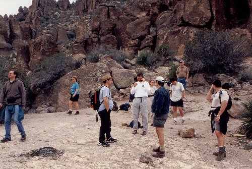 Fremont Saddle at last! |
|
We are, after all, the Trailblazers from the Motorola Hiking Club, and, as such, we do not merely stop at the saddle and then turn back like most, but go the extra mile (actually, a little more than a mile) to investigate this strange needle more thoroughly, up close and personal. The Peralta Trail soon starts to drop down rapidly from the north slope of the saddle, as it goes into a small series of switchbacks (not again!), before finally emerging from Peralta Canyon and depositing us along the western wall of East Boulder Canyon. Our morning cloud cover is starting to break up now, and the white-gray skies are gradually yielding to blue again, as we make our 450-foot descent to the base of Weaver’s Needle. Hiking through the scenic East Boulder Canyon, the discussion soon leads to the topic of gold. Gold! — hidden treasures of gold buried away deep within the remote recesses of these rugged canyons (perhaps near the base of the needle itself?), tales of mysterious lost mines, stories of half-crazed men driven nearly insane with gold fever, of men mysteriously vanishing without a trace in these mountains, talk of Jacob Waltz and the Lost Dutchman Gold Mine. Fact or fiction? You be the judge. It’s all part of the legend and the legacy of this ruggedly beautiful, but often unforgiving place called the Superstitions. A mile or so into our descent, and we are now at last on the floor of East Boulder Canyon, approaching the west side of Weaver’s Needle. The needle opens up dramatically as we draw nearer, revealing two separate spires, the tallest thrusting upward over 1200 feet from the canyon floor and reaching an elevation of 4,553 feet. We keep a sharp lookout for rock climbers, who sometime camp out overnight on the summit of the needle after making their ascent up this steep, sheer-walled volcanic plug that was named after legendary Indian scout, trapper, miner, and mountain man, Pauline Weaver. Yes, the name really is Pauline. Can you imagine the fist-fights he must have gotten into over that moniker? Made a better mountain man out of him, no doubt, always fighting to defend his name. |
 Weaver’s Needle from East Boulder Canyon. |
|
We soon hear from our hungry point lead, Loyd Cook, asking when we are stopping for lunch. I ask him to keep an eye out for a large, open camping area I had heard about earlier. Finally, at about 10:45 AM we reach our final destination and lunch stop at Pinyon Camp, a flat shaded area just to the north of the base of Weaver’s Needle and 1.6 miles from the saddle. Sugar Sumacs and Pinyon Pines would shade us from the full overhead sun, and large and abundant boulders would provide us with resting places, as we eagerly broke out lunches, snacks, and drinks. This hungry crowd was ready to chow down. We had hiked almost four miles and gone through over 1800 feet of elevation change, and we would do it all again on the way back out. Although not a great distance, much of it was over very rough and rocky terrain, with quite a bit of boulder hopping involved. We were now ready for a long, leisurely lunch and rest break in our shady retreat besides this most visible of landmarks in the western Superstitions. We had definitely earned it. The late morning temperature now stood at a very pleasant 70°F., as we talked among ourselves, while admiring the great views and refueling our bodies for the long trek back through this land of legends and mystery known as the Superstitions. |
 Top of Page
Arizona Trailblazers Hiking Club, Phoenix, Arizona
Comments? Send them to the AZHC .
updated February 12, 2019