Outdoor Links
Hike Arizona
Trip Planning Guide
Trip Report Index
Calendar of Events
Library
|
Meadow-Sinkhole Loop Mogollon Rim September 19, 2020 by Ted Tenny |
|
 We all met at Rim Top Trailhead. |
| Michael, Abhi, Randall, Ted, Sylvia, Laura, Debbie, Natalie |
|
Eight ebullient Trailblazers gathered at Rim Top Trailhead to hike the Meadow-Sinkhole Loop or one way from Rim Top Trailhead to Two Sixty Trailhead. The temperature was in the 60s, with a hazy sky. Thanks to Michael Humphrey for leading the group from Rim Top to 260! After introductions the groups parted ways. Debbie and Sylvia went with Michael and everyone else went with me. My group drove to the Military Sinkhole Trailhead, parked, and trooped the loop clockwise. |
 Laura and Natalie at the Military Sinkhole overlook. [photo by Laura] |
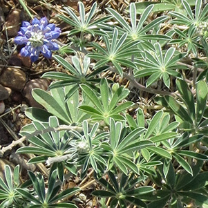
 Late summer wildflowers. |
|
The Rim Lakes Vista Trail has many outstanding overlooks west of the Military Sinkhole. They tend to be less obstructed than on the east side. You can see Two Sixty Trailhead from the Rim Lakes Vista Point, but you can’t see any lakes. Methinks the trail and the point are misnamed. |
 Many unobstructed views on the Rim Lakes Vista Trail. [photo by Abhi] |
 Part of the Rim Lakes Vista Trail is paved. [photo by Abhi] |
|

|
| Late summer wildflowers. | |
 All right, Wise Guy, who did this? |
 This rock is cracked, I say. |
 You can tell Alligator Juniper by its bark. |
 Each color of lichen is a different species. |
 Abhi, Randall, Natalie, Laura, Ted. [photo by Abhi] |
 Laura at the Meadow Trail sign. [photo by Abhi] |
|
The General Crook Trail is marked with chevrons tacked to some of the trees—yellow for the historic route used by General George Crook and white for the re-routed trail. We saw only white ones today, but there are some yellow ones along the road leading to Rim Top Trailhead. They were put up by horseback riders, so you can see them from far away. |
 Some of the trees are marked with chevrons on the General Crook Trail. |
 Abhi, Randall, Laura, Natalie, Ted. [photo by Abhi] |
 Natalie and Laura. [photo by Randall] |
 Ted and Abhi. [photo by Randall] |
|
The Military Sinkhole is where General George Crook used to water his Army livestock, 150 years ago. The trail goes on the east side, but the deepest part is on the west side. |
 Autumn color in the Military Sinkhole. |
 The deepest part of the Military Sinkhole is on the west side. |
 Ferns at the Military Sinkhole. [photo by Laura] |
 We’re almost out of the woods. [photo by Laura] |
|
Soon we were back at the trailhead. “Thank you all for hiking with me,” I told everyone. |
|
Supplemental Report by Sylvia Lee |
|
We parked at the Rim Vista parking lot. After greetings and introductions four hikers chose to go with Ted Tenny on a 4-mile loop. Debbie and I followed Michael Humphrey on a 6-mile loop that gained some footage as we went along. |
 Our hike begins here. [photo by Sylvia] |
 Rim Top Trailhead. [photo by Sylvia] |
|
We three started from the trail sign above. Someone had carved this seat from a dead stump. A person could sit in relative comfort while waiting for fellow hikers to appear. We walked thru the woods, crossed the paved highway, and read this sign. |
 Trail sign, just across the road. [photo by Sylvia] |
 One of the many outstanding overlooks. [photo by Sylvia] |
|
We passed the intersection with the Military Sinkhole Trail and continued on the Rim Lakes Vista Trail. Debbie and Michael posed for me at one Rim Vista. Lovely smiles on their faces. |
 Debbie and Micheal. [photo by Sylvia] |
|
When the Rim Lakes Vista Trail was not showing off the Rim and its views it was showing off the finery of late summer foliage and flora. It was a one-person-wide trail as you can see. |
 Michael knows the way. [photo by Sylvia] |
 Only 3 miles to Rim Top Trailhead. [Sylvia] |
 Escarpment of the upper layer of the Mogollon Rim. [photo by Sylvia] |
|
This photo provides a good view of the escarpment of the upper layer of the Mogollon Rim. After walking about three-and-a-half miles we stepped onto the Meadow Trail that took us perpendicularly away from the Rim. In about a quarter of a mile we came to the General Crook trail and started along it. The General Crook Trail ended at the place where our vehicles were parked. About halfway down this trail, actually a graded electric-and-telephone line maintenance road, Debbie and Michael took the trail to the Military Sinkhole. From there they would backtrack along a portion of the Rim Lakes Vista Trail to reach their vehicle. I was tired and had slowed down a lot so I stayed on the General Crook Trail, which was flat and easy to walk on. |
 This road leads back to Rim Top Trailhead. [photo by Sylvia] |
|
A long walk thru the ponderosa forest with occasional colors of flowers and ferns. I was the last person to arrive at the parking lot. Debbie and Michael had walked more mileage than me but had done it much faster. It took me 3½ hours to walk about 6¾ miles at an altitude of slightly above 7,000 feet. Had been a good day for me. This is also posted on my blog. |
 Top of Page
Arizona Trailblazers Hiking Club, Phoenix, Arizona
Comments? Send them to the AZHC .
updated September 20, 2020