Outdoor Links
Hike Arizona
Trip Planning Guide
Trip Report Index
Calendar of Events
Library
|
Mt. Ord Day Hike Mazatzal Mountains April 3, 2014 by Bill Zimmermann |
|
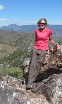
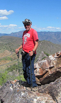
 Eileen, Bill, and Nancy on the top of Mt. Ord. |
|
7:10 AM, clear skies, no wind, and thirty-six degrees. We were ready for a long walk up a big hill. Nancy, Eileen, and Bill were on our way. The hike followed an old road. Can you believe it, no off-trail? It was the first time for ladies. Bill had done it in December, 2008. |
 Eileen and Nancy at Slate Creek. |
 We start with the sun shining ... |
 but encounter snow at the higher elevations. |
 Grand overview of Roosevelt Lake. |
 Mt. Ord communication towers. |
The Forest Service had made some major improvements at the beginning where the road crosses Slate Creek. Chicken-wired rock barriers and the guardrail were new. We carried extra water. After climbing the first 1000 feet we ditched some at “W” for a lighter load to carry the next 2700 feet (sort of). We adjusted clothing layers. At the lower levels we were in and out of the sun. Eileen did some footwear adjustment to fight off a hot spot. She added a sock. At “RX” the old road connected with the major road ... great surface and the start of the pines. I forgot to mark the waypoint, but I think was after “62” that we got our first glimpse of Roosevelt Lake. After a second foot adjustment by Eileen, we were on our way. Roosevelt then remained out of site until we reached the top. |
|
|
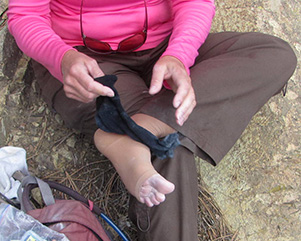
| Owww! | |
|
We passed snow-covered hillsides sheltered from the sun. We reached the top at about 11 AM. Here we explored some, enjoying the panoramic view as we tried to identity the peaks, roads, trails, and lakes. While having lunch we added layers as an unfriendly cloud hid our sunshine. The group picture was a hurried affair as our fingers were starting to get numb from the cold. |
 Nancy and Bill identify distant landmarks. [photo by Eileen] |
 Agave can take the chill. [photo by Eileen] |
 Calochortus ambiguus - Doubting Mariposa Lily |
 Nancy |
 Bill |
 Eileen |
|
We postponed relacing our boots for the downhill until our fingers thawed. It was gloves for all and a nose warmer for some. Partly sunny became partly cloudy as we worked our way down. Two water stashes (in addition to ours) were still there on our return. We left them. Saw no other people. We had enough energy to explore a few off-trail rock outcroppings. One appeared as some mining structure. The other was ideal for a photo shoot. |
 Eileen knows it’s cold! |
 Roosevelt Lake, through the pines. |
 I can see your point, but ... |
 Slate Creek looks mighty good on the way back. |
 Nancy and Eileen find a concrete foundation. |
|
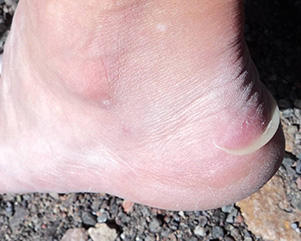
15.8 Miles ... 3726 Feet ... One Blister ... not bad. |
 Top of Page
Arizona Trailblazers Hiking Club, Phoenix, Arizona
Comments? Send them to the AZHC .
updated May 26, 2021