Outdoor Links
Hike Arizona
Trip Planning Guide
Trip Report Index
Calendar of Events
Library
|
Rim Vista Loop Day Hike Sitgreaves National Forest August 4, 2007 by Ted Tenny |
|
 18 Terrific Trailblazers troop the loop on the Mogollon Rim. |
|
I got up early to get ready for the hike, when the telephone rang. It was a hiker asking whether we were going on the hike despite last night’s rain (hikers note: You don’t have to call. I’ll notify everyone if the hike is canceled). “The hike is on,” I assured him. |
 Yellow chevrons mark the historic General Crook Trail.  Look lively now! Don’t splash in the water. |
Rain peppered against my car’s windshield as we drove toward Payson. But it didn’t last. We pulled into Rim Top Trailhead under a cloudy sky, but the rain held off until after our hike. It was a mild day with clean air and a pleasant breeze. The General Crook Trail was a military supply route across the top of the Mogollon Rim. The original route, marked with yellow chevrons, is now a forest road closed to motor traffic. White chevrons mark the hiking trail where it leaves the road. We pass a preserve that has been fenced off to protect the saplings from being eaten by the local wildlife. Then we watch carefully for the markers to show us where the trail leaves the road. Everything is so wet! We must have arrived just after a big rainstorm, because there’s water flowing beside the road and standing in all the low places. |
|
When we see those white chevrons on the left, our turnoff is flooded. So we walk on down the road until we can get over to the trail without splashing in. The trail itself is partly under water. We can sort of get around it by walking on the rocks, but we’re so close to the road that there doesn’t seem much point in it. So everyone returns to the road. Its surface is soft but not quite muddy. There’s no dust today. |
|
Up ahead, our trail leaves the road on the right side. It isn’t quite as flooded, so we make another attempt to sort of follow the trail without wading in the water. Soon we arrive at the junction with the Military Sinkhole Trail. Here we turn left and go south to the sinkhole, which isn’t flooded. Then we cross the Rim Road (Forest Service Road 300) and stop for a snack and group pictures. The rest of our hike is on the Rim Vista Trail, so I decide to sweep. “Don’t turn on any trails branching off to the left,” I advise everyone. The Rim Vista Trail goes along the edge of the Mogollon Rim, with scenic overviews from the rock formations. We stop many times to take pictures while the other hikers go on ahead. This is Zane Grey country! Light and shadows, rocks and forest, give us many fantastic photo-ops. |
 My, but isn’t it grand from here! 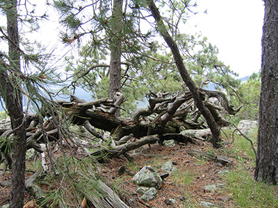 What disaster befell this twisted tree? |
|
We discuss the relative merits of SLR film cameras vs. compact digital cameras for hikers. |
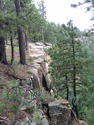 You’re on the Mogollon Rim. Look before you leap. |
The trail crosses a freely-flowing stream which cascades down in a series of little waterfalls. My camera’s light meter says it’s too dark to take pictures without a flash. If only the sun were shining! A lot of trees have fallen over since the last time I was here. Tree trunks block the trail, with dense vegetation on either side. At one point it looks as if we can walk off-trail along the rim and get around the fallen tree trunks, but the vegetation keeps us from returning to the trail. So we double back to the trail and ease our way over the tree trunks. The trail takes us out to the rim, one last time. At this point we can hear the traffic on highway 260, which we can see right below us. |
|
We leave the rim and head north through the forest. The trail is relatively dry at first, as we are going uphill. |
 Here’s the trail, all right. But where are my pontoons? |
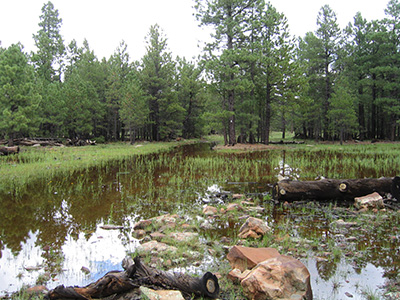
Then we get to the flood zone. The ground is almost level, so this morning’s rains have left water standing everywhere, with no place to go until it can slowly drain away. We try to go around the pools of water, first on the right and then on the left. Finally we take a big detour at Forest Road 300, and soon reach the trailhead. |
|
What a lovely day to escape the summer heat and walk in the clouds! |
|
 Top of Page
Arizona Trailblazers Hiking Club, Phoenix, Arizona
Comments? Send them to the AZHC .
updated July 3, 2019